I heard somewhere about a Scottish custom called walking the boundaries. As I recall, this annual event gathered all the landowners in an area to troop around the boundary lines, then probably go eat. It seems like a good practice to get together with your neighbors yearly to witness the borders of each landholder’s grounds, make sure everyone’s fences are in good order, and remind everybody of who owns what. It’s a community affirmation that probably prevented a lot of disputes.

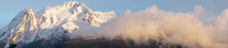
Looking south down Lynn Canal from "The Knoll" (Mark Zeiger photo).
I thought of this today during a family outing. We’d been planning for a while to take a hike to “The Knoll” on the ridge behind the cabin. It may or may not be part of our property, which is why we took our hand held GPS. We planned to walk our boundaries and learn what was where.
The previous owner talked about the place as if it were part of the property. However, because the terrain’s so rough, it’s almost impossible to walk a straight line. We can’t tell for sure if it’s on our side of the northern boundary line, or the neighbors’. It really doesn’t make much difference. Despite our fantasies of building a little bungalow up there, it isn’t a parcel that will ever be developed. We just really like it there, and would love to know for sure whether it was a part of our property or not.

LC Mountain from "The Knoll" (Mark Zeiger photo).
Taking a GPS reading on the knoll, then comparing it to the location of our property pins seemed like a good idea. Unfortunately, it didn’t work well. The GPS is more effective where there are no trees to keep it from communicating with satellites. We probably got a good fix on the knoll, but the pins were terrible. I had old readings on the beach side pins, which seemed way off. I reset the north one, hiked down and set the south one, then returned to the north one. Standing over the pin, my GPS said it was 30 feet away! I made a new marker, but who’s to say the new reading is the correct one? Another day I’ll try setting the unit on each pin and leaving it for a good long while before marking the location. Maybe that’ll improve the readings.
So, we didn’t discover anything new about our land holdings today. We did have a very pleasant family hike, though, and we detoured along our nearest neighbor’s trail to remove windfalls before they come home next week.